
The day nature humbled Jamaica
Today is the 119th anniversary of the 1907 earthquake and fires which burnt down Kingston
HURRICANE-FATIGUED Jamaicans might not be in any mood to hear about disasters, but at 3:30 pm today, Jamaica will mark the 119th anniversary of the 1907 earthquake which lit devastating fires across Kingston and badly damaged several rural towns.
It is a safe bet that no Jamaican alive was around or old enough at the time to recount the hellish experience of that disaster, which was described by the United States Geological Survey as “one of the world’s deadliest earthquakes recorded in history”.
The editorial on page 12 of today’s Jamaica Observer is spot on in its stark reminder that preparedness is key:
“Jamaica’s vulnerability to earthquakes is not theoretical. The island sits astride a complex system of active fault lines along the boundary of the Caribbean and North American tectonic plates.
“History bears sober witness to this reality, from the devastating 1692 earthquake that destroyed much of Port Royal to more recent tremors that have reminded us how suddenly the ground beneath our feet can shift…”
The 1692 earthquake, often romanticised as hitting the “wickedest city on earth”, was, from all historical accounts, a real baddie. But it paled in its destructive effect compared to the 1907 event.
Jamaica’s National Library said the earthquake was at magnitude 6.5 when it struck Jamaica on January 14, 1907. The damage moved from the capital to other towns including Port Maria and Annotto Bay, St Mary and Buff Bay, Portland.
“In Kingston, the earthquake resulted in severe infrastructural damage to roadways, pipelines, railways, electrical poles, homes, churches, business places and schools. The busy commercial district of Kingston came to a virtual standstill after the earthquake rocked the city, resulting in over 1,000 deaths and millions of dollars in damage,” the archive said.
Wikipedia, which drew on several different historical sources, was even more dramatic.
“Every building in Kingston was damaged by the earthquake and subsequent fires, which lasted for three hours before any efforts could be made to check them… Eighty-five per cent of buildings were destroyed by the shaking, which was followed by a fire that destroyed parts of the business and warehouse districts.
“Shortly after, a tsunami was reported on the north coast of Jamaica, with a maximum wave height of about 2 m (6-8 ft)…
The Elder-Dempster passenger steamer Port of Kingston, which was under repair in Kingston Harbour at the time, was threatened by fire on the nearby wharf. A rapid temporary repair allowed her to be moved to the safety of an unaffected railway wharf.”
It was reported that the Port of Kingston, the only passenger ship in the Kingston Harbour, was used as a makeshift hospital, with improvised operating theatres in three parts of the ship and on the adjoining wharf.
“Kingston Public Hospital, despite loss of its water supply, continued to function throughout the following night. Three United States Navy warships, the battleships USS Indiana and USS Missouri and the destroyer USS Whipple, landed men and supplies on 17 January, although an offer of eight surgeons was rejected by Governor of Jamaica Alexander Swettenham… A suspension bridge was destroyed at Port Maria.
“The main shock lasted for about 35 seconds after some minor initial tremors and was accompanied by a roaring sound. The intensity of the shaking grew quickly to a first and strongest climax. The intensity then lessened before again reaching a second weaker climax. There were 80 aftershocks recorded up to 5 February, while the strongest of all was recorded on 23 February.”
According to the records, the only seismograph in Jamaica at the time was put out of action by the earthquake. The rupture may have been on an eastward continuation of the South Coast Fault Zone, within the Wagwater Belt or in the Blue Mountains.
“The greatest felt intensity was noted for areas built on unconsolidated sands and gravels. To the east of Kingston, along the Palisadoes, there were sandblows and surface faulting associated with areas of subsidence and flooding,” it said.
“After the earthquake, tsunami were observed along much of the north coast of Jamaica … There were also some reports of waves along the south coast. Seiches (temporary disturbance caused by changes in atmospheric pressure) were reported in Kingston Harbour.
“The level of the sea at Annotto Bay was reported to have initially dropped by more than 3 metres (9.8 ft), as the sea withdrew a distance of about 80 m (260 ft), before returning at a height of about 2 metres (6 ft 7 in) above normal, flooding the lower parts of the town.”
Until January 17, the Office of Disaster Preparedness and Emergency Management (ODPEM) will be marking Earthquake Awareness Week.
Hurricane Melissa woes or not, we better all heed the warnings.
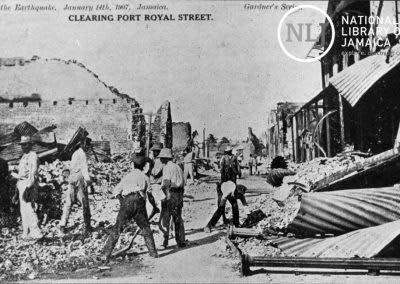
Workmen clearing debris on Port Royal Street in Kingston in the aftermath of the 1907 earthquake. (Photo: Jamaica National Library Service)


